
Conservation Land
Lancaster Conservation Lands and Canoe Launches
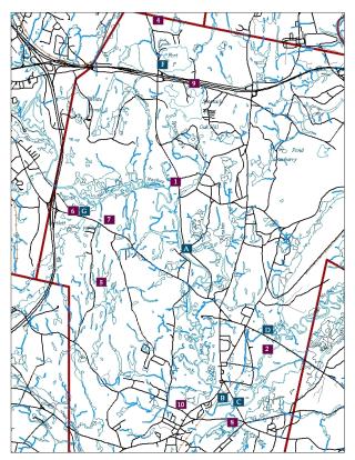
- Cook Conservation Area and Lancaster State Forest - About 800 acreas owned by Lancaster Conservation Commission, located a mile an a half from Route 117 on the west side of Lunenburg Road, Route 70. This connects to the Chapman/Goodale land that extends into Leominster. Parking is available. A six-mile trail runs along the North Branch of the Nashua and returns by cart paths.
- Bolton Flats Management Area - 923 acres oened by the Division of Massachusetts Fisheries and Wildlife. There are two parking areas on either side to Route 117. The largely flat interval includes walks along the main stem of the Nashua. Beware of opening day of hunting season in the fall. Sundays are good days to go, hunting is not allowed, then.
- Oxbow National Wildlife Refuge - 711 acres owned by the U S Department of Fish and Wildlife. Parking and canoe access off Still River Depot Road in the Still River section of Harvard. This is a good birding area with oxbow ponds, river greenway and wetlands. Good winter access. It is buggy in the spring and early summer.
- Turner Pond Conservation Area - 38 acres owned by Lancaster Land Trust. Parking at the Brian Road cul-de-sac, off Kaleva Road, which is off Lunenburg road just north of Route 2. The access road runs between two developments on either side of Turner Pond, a glacial kettle hole pond. A spruce bog is on the north side of the pond.
- Lancaster Town Forest - About 600 acres on both sides of Brockelman Road owned by the Town of Lancaster. Parking is available. Paths run along several ponds and wetlands.
- Bartlett Pond Conservation Area - About 20 acres owned by the Conservation Commission on Route 117 by Route 190. Paved parking lot with access to Bartlett Pond.
- Ballard Hill Conservation Area - 34 acres on the north side of Route 117 at the top of Ballard Hill, owned by the Lancaster land Trust. Parking lot is next to 2273 Main Street. This land connects to about 600 acres of open land. Walk down pole line to the North Branch of the Nashua River, or follow the cart path west of the pole line.
- Atherton Bridge River Greenway - Conservation Commission land on the south side of Bolton Road. Trail runs along the east side of the South Branch of the Nashua.
- Lancaster Town Beach - On Old Union Turnpike east of Route 70, Lunenburg Road. Beach sticker is required. Swimming, but no boating.
- Dexter Drumlin - 35 acres donated to the rustees of the Reservations by town father Nathaniel Dexter and located on George Hill Road across from Browning Elementary. Parking is on the road. This glacial deposit from 12,000 years ago, offers sledding and cross-country skiing in the winter and scenic walking area year-round. Dogs are allowed on leashes. Great kiting at the top of the hill.
Canoe Launches
- Ponakin Bridge - Abandoned bridge on the west side of Lunenburg Road on Route 70 about one mile north of Route 117.
- Main Street Bridge - Access path on the east side of Route 70, Main Street just south of Lancaster Center.
- Center Bridge - At the Meeting of the Waters, where North and South branches of the Nashua River converge into one stream. Limited parking.
- Route 117 Bridge - About one mile west of Route 110 near Culley’s Snowmobile Ranch and Bolton Flats. Limited parking.
- Oxbow National Wildlife Refuge - Located in the Still River section of Harvard off Route 110 at the end of Still River Depot Road. Plenty of parking with canoe access from parking lot.
- Fort Pond State Boat Launch - On Fort Pond Road at Route 70, Lunenburg Road.
- Pond Conservation Area - Parking and launch on Route 117 just east of I-190.
- I-190 Bridge - Park at the turn-around at the end of North Main Street. Paved path goes under I-190.